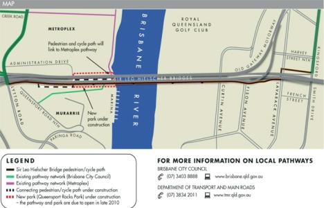
I received a question from keen Brisbane walker, Alayne, who asked about access to the walking path over the new Gateway Bridge (officially named the Sir Leo Hielscher Bridge).
Alayne, access from the south side of the bridge is from Lytton Road. There is space for parking on the shoulder of Lytton Road on the east side of the bridge. At the moment, it looks like a bit of a construction site with the Lytton Road off ramp still being finished. However, don’t be put off by the construction because there is pedestrian access beside the barriers.
On the north side, parking is on Lavarack Avenue with access to the pedestrian path between Harvey Street North and French Street.
Late in 2010, new parkland with car parking, will open up under the south side of the bridge, and this will link up with the pedestrian pathway over the bridge. So this will be the best place to start a walk over the new Gateway Bridge. I’ll write up a walk description and map once it’s all completed.
In the meantime, below is a map which comes from an information sheet produced by the Gateway Upgrade Project information office. You can download a more printer-friendly information sheet with the map (on page 2 of the PDF) from their website.
By the way, the people who work in the Community Relations Team for the bridge upgrade (freecall 1800 700 525) are really friendly and helpful if you have any questions about walking or cycling access.
I’m a bit embarrassed to say that I have yet to walk the full length of the bridge (I only got 200 metres onto the bridge on the crowded open day). I’ve been busy writing my next walking guide book which is for the Sunshine Coast. So if anyone would like to give the bridge a ‘walking review’ please use the comments section or email me: editor (at) brisbanewalks.com.au.
Filed under: Activities, Families, Places to visit, Walks | Tagged: Gateway Bridge, walks |


Hi,
As residents of Murarrie located on the Southside of the Gateway Bridge, we find it convenient to get onto the walking path on the new bridge and enjoy the cool breezes, scenery and uninterrupted exercise one gets walking to the North and back, either in the mornings or evenings. The walk path is well lit and the concrete surface clearly marked, and has at least three rest areas with drink fountains, benches, telephone and glass panelled lookout “windows” in the mesh safety fence. The walk is invigorating to say the least and promotes good health (tongue in cheek!) if committed to a regular regime. Certainly helps us. On a minus point, seeing that it is also a tourist attraction as well, or will become one in due course, it is suggested that the authorities concerned consider displaying the distance of the walk at the start of the walk on each end of the bridge. Also, it would not go astray to write up and display in similar locations some of the prominent features of the bridge construction, for example: some specifications, overall length and width, date built, etc.
cheers,
glenn and jenny Todd.